
Weather Data For Garmin InReach and Others
If you are using sailmail or winlink email systems, I do not recommend you use this service. See our other weather page for services that are more compatible with larger text and gribs.
Garmin and other companies have a few text based email devices that are good for retrieving short messages. This service is primarily for InReach users, but it will work from any email device with no access to grib or normal long text messages like email.
Quick start
Email one command to wx@svsarana.com. For an InReach that has locked GPS at your current position, start with:
gfs
For a specific position, include latitude and longitude:
gfs 20N 155W
For a 48-hour forecast converted to Hawaii time:
gfs 20N 155W 48 utc=-10
A blank InReach message defaults to a 24-hour spot forecast using the device’s reported position.
What is this?
This is a tool for you to send extremely short requests and get extremely short messages of 160 characters each back. It caters to the Garmin InReach device, but there might be others out there that find it useful.
See InReach and tethered-phone examples
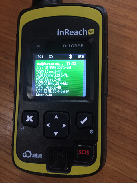
An InReach device receiving a response from wx@svsarana.com:
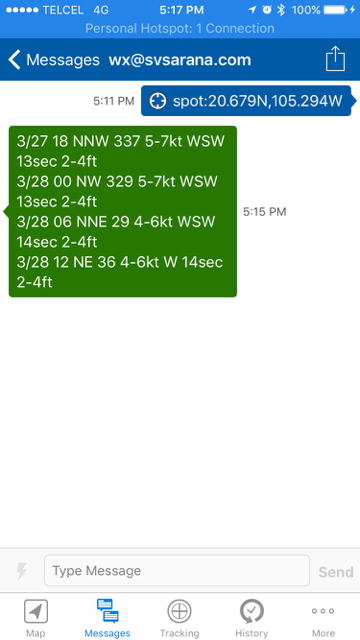
A phone tethered to a compatible InReach device:
Choose a forecast
| Need | Start with | Example |
|---|---|---|
| Weather at a position, including land | gfs | gfs 20N 155W |
| Compact wind and sea forecast | spot | spot 20N 155W |
| Wave forecast | ww3 | ww3 20N 155W |
| Ocean currents | rtofs or roms | rtofs 20N 155W |
| WMO marine bulletins | metcat | met3a |
| NOAA coastal zones | catalog | PMZ021 |
gfs for land positions.An InReach supplies its GPS position automatically, so commands such as gfs, spot, and ww3 do not require coordinates as long has your device has a locked position.
A blank InReach message defaults to a 24-hour spot forecast. Other email devices should include a position.
Coordinates can use spaces, commas, colons, or pipes:
12.3N 155W
12.3N,155W
12.3N:155W
12.3N|155W
Position command options
Some keyboards like on the InReach, using a space or comma might be most convenient for separating options. For rtofs, gfs and spot commands you can follow them with the Lat,Lon and some other options and you can use any of the following characters to separate the options so all the following examples with latitude and longitude values are valid:
General Form: spot:lat,lon|hours|heading,speed|utc=offset|stats
Delimiters: [space][comma][colon][pipe] ==> [ ][,][:][|]

spot 10N 155W
spot:10N:155W
spot:10N 155W,utc=-7
spot|10N|155W|utc=-7|stats
spot,10N,155W,utc=-7,stats
HOURS option
In general if hours is not specified it assumes a 24 hour time period and does it’s best to just send a single message back. Sometimes it doesn't all fit in one response, but in general the default 24 hours will try to produce the most compact result. You can set hours to 24 up to 96 in 6 hour increments. Remember that the longer the forecast the more messages required to send the information
HEADING,SPEED option
This ONLY works for the SPOT model, right now. You can request a forecast along a path using the heading as true degrees and the speed in knots. The forecast will then use your time interval specified by HOURS (or if not specified, 24 hours is assumed) and will compute a series of latitude and longitude points and provide a forecast along that line. If you plan on sailing at 150 degrees at about 5 knots, use this example. Spaces are shown, but commas, colons, or pipes can also be separators:
spot 12n 150w 150 5 utc=-10
Note: Heading and speed must be used together, in that order.
UTC Option
To convert the dates and times to your local zone, use the UTC option to tell the forecasting software what your time zone is. For example Mexico is -7 or -8 depending on daylight savings and your time zone. Hawaii is -10
STATS option
The "stats" provides a statistical average from the forecast, which is good for just getting a long term overview in 24/48/72 hours.
spot,10N,155W,utc=-7,stats -- produces the following response for wind predictions:
24hrs: max/avg/min 12-17/11.2-15.4/10-14 @ 17.8
48hrs: max/avg/min 12-17/10.2-13.9/8-11 @ 11.4
72hrs: max/avg/min 12-17/9.2-12.6/6-9 @ 7.5
The ranges represent the values found during any given prediction interval. So for max wind 12-17 this means there were some
forecast values that only had max winds to 12 knots, whereas there were some other forecast results that had 17. For example if a
forecast had the following characteristics:
hour 1 - 10-12
hour 2 - 14-17
hour 3 - 15-16
The STATS shows max ranges from 12 - 17 for this time interval. The @ direction in degrees represents the geometrical average
of the wind direction over that time frame.
InReach-specific options
The InReach sends its current GPS position automatically. To use that position, send one of these commands without latitude or longitude:
spotgfsgfdlrtofsww3roms
The default forecast length is 24 hours. A blank message uses spot.
WMO METAREA / GMDSS forecasts
The service can retrieve marine warnings and forecasts from the WMO Worldwide Met-Ocean Information and Warning Service. The available products change as national weather services publish or withdraw bulletins, so first request a catalog if you do not already know the command.
metcat          list all METAREA commands
met3            list the products currently available for METAREA III
met3a           retrieve one METAREA III product
met3a,met3b     retrieve more than one product
Be careful when requesting multiple or long products: responses are divided into blocks of approximately 160 characters, and some InReach plans charge for each block. A warning or high-seas forecast may require several messages.
METAREA command map
WMO divides METAREA VIII into North and South: met8 and met9 represent those two regions.
Beginning with met10, the command number is one greater than the official METAREA number.
met1  - METAREA I          met12 - METAREA XI
met2  - METAREA II         met13 - METAREA XII
met3  - METAREA III        met14 - METAREA XIII
met4  - METAREA IV         met15 - METAREA XIV
met5  - METAREA V          met16 - METAREA XV
met6  - METAREA VI         met17 - METAREA XVI
met7  - METAREA VII        met18 - METAREA XVII
met8  - METAREA VIII North met19 - METAREA XVIII
met9  - METAREA VIII South met20 - METAREA XIX
met10 - METAREA IX         met21 - METAREA XX
met11 - METAREA X          met22 - METAREA XXI
Example subcatalog: METAREA III
Sending met3 returns a current subcatalog similar to this:
met3a - East / High Seas Warning
met3b - East / High Seas Forecast
met3c - West / High Seas Forecast
met3d - Cyprus Forecast
met3e - CROSS La Garde Forecast
met3f - Irakleio Forecast
met3g - Kerkyra Forecast
met3h - Limnos Forecast
met3i - Cabo La Nao Forecast
met3j - Tarifa Forecast
The letter assigned to a product is generated from the current WMO catalog and can change when products are added or removed.
Check met3 again if an older product command stops working. You can also inspect the
current METAREA III page manually.
When WMO has no products for an area, wx-sms returns a short “No reports currently available” response instead of a blank message.
Full current METAREA product catalog
Open this section to load the current WMO products, or open the catalog on its own page.
Model background
| Command | Model and coverage |
|---|---|
spot | Compact virtual-buoy forecast combining GFS wind with WW3 sea state. |
gfs | Global wind, temperature, and experimental precipitation over land and ocean. Model information. |
gfdl | Low-resolution daily climate model with wind and cloud coverage. |
rtofs | Global ocean-surface currents. Model information. |
ww3 | Global wave model providing combined seas, swell, and wind waves. Model information. |
roms | Ocean currents around Hawaiʻi only. Model information. |
Example WW3 response and abbreviations
-----MESSAGE 1-------------------
03/13 23 Pk: 9.1' NNW 13s, S: 7.6' N 13s, WW: 4.9' ESE 7s
03/14 02 Pk: 9' NNW 12s, S: 7.1' N 13s, WW: 5.5' ESE 7s
-----MESSAGE 2-------------------
03/14 05 Pk: 9.1' NNW 12s, S: 6.4' NNW 12s, WW: 6.2' ESE 6s
03/14 08 Pk: 9.2' NNW 12s, S: 6' NNW 12s, WW: 6.9' ESE 7s
-----MESSAGE 3-------------------
03/14 11 Pk: 8.9' NNW 12s, S: 5.6' NNW 12s, WW: 6.9' ESE 7s
03/14 14 Pk: 8.6' NNW 12s, S: 5.2' NNW 12s, WW: 6.9' ESE 7s
-----MESSAGE 4-------------------
03/14 17 Pk: 8.5' NNW 11s, S: 4.9' NNW 12s, WW: 7' ESE 7s
03/14 20 Pk: 8.7' NNW 11s, S: 4.7' NNW 11s, WW: 7.3' ESE 7s

Pk: This is the total peak wave composite of swell + wind waves.  Height in feet, Direction and period
S:  This is the SWELL with height in feet, direction and period
ww: This is the Wind Waves with height in feet, direction and period
New models may be added as useful low-bandwidth products become available.
NOAA coastal zone forecasts
Send catalog to list the available three-letter regions, such as PMZ, PZZ, and PHZ.
Send a region to list its individual forecast zones, then send a six-character zone such as PMZ021 to retrieve the forecast.
catalog → PMZ → PMZ021
Mexico, Central America, and northern South America zones
code => description
PMZ001 => 'SYNOPSIS FOR THE E PACIFIC WITHIN 250 NM OF MEXICO',
PMZ009 => 'MEXICO BORDER S TO 29N WITHIN 60 NM OF SHORE',
PMZ011 => 'MEXICO S OF 29N TO PUNTA EUGENIA',
PMZ013 => 'PUNTA EUGENIA TO CABO SAN LAZARO TO 250 NM OFFSHORE',
PMZ015 => 'CABO SAN LAZARO TO CABO SAN LUCAS TO 250 NM OFFSHORE',
PMZ017 => 'NORTHERN GULF OF CALIFORNIA',
PMZ019 => 'CENTRAL GULF OF CALIFORNIA',
PMZ021 => 'SOUTHERN GULF OF CALIFORNIA',
PMZ023 => 'ENTRANCE TO THE GULF OF CALIFORNIA AND CABO CORRIENTES',
PMZ025 => 'MEXICO - MICHOACAN AND GUERRERO TO 250 NM OFFSHORE',
PMZ027 => 'MEXICO - OAXACA AND CHIAPAS INCLUDING TEHUANTEPEC'
PMZ101 => 'Synopsis for the E Pacific within 250 nm of C.A., Colombia, and 750 nm of Ecuador',
PMZ111 => 'Guatemala and El Salvador to 250 nm offshore',
PMZ113 => 'El Salvador to North Costa Rica including the Gulfs of Fonseca and Papagayo',
PMZ115 => 'North Costa Rica to West Panama to 250 nm offshore',
PMZ117 => 'East Panama and Colombia including the Gulf of Panama',
PMZ119 => 'Ecuador including the Gulf of  Guayaquil to 250 nm offshore',
PMZ121 => 'Ecuador between 250 and 500 nm offshore',
PMZ123 => 'Offshore Galapagos Islands'
These forecasts are sourced from NOAA/NHC products. For example, sending PMZ021 returns the Southern Gulf of California forecast.
Example PMZ021 response
-----MESSAGE 1-------------------
PMZ021-120415-
Southern Gulf of California-
806 AM PST Sat Nov 11 2017

.TODAY E winds less than 5 kt, shifting to NW in the
afternoon. Seas 4 to 5 ft in SE to

-----MESSAGE 2-------------------
S swell. Period 15 seconds.
.TONIGHT NW to N winds 5 to 10 kt. Seas 4 ft. Period
15 seconds.
SU:NW to N winds 10 to 15 kt. Seas 4 ft. Period 18 seconds.
-----MESSAGE 3-------------------
SU:NIGHT NW to N winds 10 to 15 kt. Seas 5 ft. Period
17 seconds.
MO:NW to N winds 10 to 15 kt. Seas 5 ft. Period 17 seconds.
MO:NIGHT NW to N winds 10 to 15
-----MESSAGE 4-------------------
kt. Seas 4 to 5 ft. Period
16 seconds.
TU:NW to N winds 10 to 15 kt. Seas 4 ft. Period 15 seconds.
TU:NIGHT NW winds 10 to 15 kt. Seas 4 ft. Period 14 seconds.

-----MESSAGE 5-------------------
WE:NW to N winds 5 to 10 kt. Seas 3 to 4 ft. Period
17 seconds.
WE:NIGHT NW winds 5 to 10 kt. Seas 3 ft. Period 16 seconds.
Days are abbreviated to reduce message size; for example, TU: means Tuesday.
Full NOAA zone reference: Hawaiʻi, Pacific coast, Alaska, Florida, Mexico, and Central America
HAWAIIAN INNER ISLAND WATERS
'HIZ001' => 'Niihau',
'HIZ002' => 'Kauai Windward',
'HIZ003' => 'Kauai Leeward',
'HIZ004' => 'Kauai Mountains',
'HIZ005' => 'Oahu South Shore',
'HIZ006' => 'Waianae Coast',
'HIZ007' => 'Oahu North Shore',
'HIZ008' => 'Oahu Koolau',
'HIZ009' => 'Olomana',
'HIZ010' => 'Central Oahu',
'HIZ011' => 'Waianae Mountains',
'HIZ012' => 'Molokai Windward',
'HIZ013' => 'Molokai Leeward',
'HIZ014' => 'Lanai Makai',
'HIZ015' => 'Lanai Mauka',
'HIZ016' => 'Kahoolawe',
'HIZ017' => 'Maui Windward West',
'HIZ018' => 'Maui Leeward West',
'HIZ019' => 'Maui Central Valley',
'HIZ020' => 'Windward Haleakala',
'HIZ021' => 'Leeward Haleakala',
'HIZ022' => 'Haleakala Summit',
'HIZ023' => 'Kona',
'HIZ024' => 'South Big Island',
'HIZ025' => 'Big Island North and East',
'HIZ026' => 'Kohala',
'HIZ027' => 'Big Island Interior',
'HIZ028' => 'Big Island Summits'

HAWAIIAN COASTAL WATERS
'PHZ100' => 'Synopsis Hawaiian coastal waters within 40 NM',
'PHZ110' => 'Kauai Northwest Waters',
'PHZ111' => 'Kauai Windward Waters',
'PHZ112' => 'Kauai Leeward Waters',
'PHZ113' => 'Kauai Channel',
'PHZ114' => 'Oahu Windward Waters',
'PHZ115' => 'Oahu Leeward Waters',
'PHZ116' => 'Kaiwi Channel',
'PHZ117' => 'Maui County Windward Waters',
'PHZ118' => 'Maui County Leeward Waters',
'PHZ119' => 'Maalaea Bay',
'PHZ120' => 'Pailolo Channel',
'PHZ121' => 'Alenuihaha Channel',
'PHZ122' => 'Big Island Windward Waters',
'PHZ123' => 'Big Island Leeward Waters',
'PHZ124' => 'Big Island Southeast Waters'

Washington, Oregon, California, Alaska
'PZZ100' => 'Washington Synopsis',
'PZZ150' => 'Coastal Waters Forecast',
'PZZ130' => 'West Entrance U.S. Waters Strait Of Juan De Fuca',
'PZZ131' => 'Central U.S. Waters Strait Of Juan De Fuca',
'PZZ132' => 'East Entrance U.S. Waters Strait Of Juan De Fuca',
'PZZ134' => 'Admiralty Inlet',
'PZZ133' => 'Northern Inland Waters Including The San Juan Islands',
'PZZ135' => 'Puget Sound and Hood Canal',
'PZZ110' => 'Grays Harbor Bar',
'PZZ300' => 'SYNOPSIS S OREGON COASTAL WATERS',
'PZZ370' => 'Waters from Florence to Cape Blanco OR from 10 to 60 nm',
'PZZ376' => 'Waters from Cape Blanco OR to Pt. St. George CA from 10 to 60 nm',
'PZZ350' => 'Coastal waters from Florence to Cape Blanco OR out 10 nm',
'PZZ356' => 'Coastal waters from Cape Blanco OR to Pt. St. George CA out 10 nm',
'PZZ400' => 'SYNOPSIS S WASHINGTON AND N OREGON COAST',
'PZZ450' => 'Pt St George to Cape Mendocino out 10 nm',
'PZZ470' => 'Pt St George to Cape Mendocino 10 to 60 nm',
'PZZ455' => 'Cape Mendocino to Pt Arena out 10 nm',
'PZZ475' => 'Cape Mendocino to Pt Arena 10 to 60 nm',
'PZZ400' => 'SYNOPSIS FOR NORTHERN CALIFORNIA WATERS',
'PZZ450' => 'Pt St George to Cape Mendocino out 10 nm',
'PZZ470' => 'Pt St George to Cape Mendocino 10 to 60 nm',
'PZZ455' => 'Cape Mendocino to Pt Arena out 10 nm',
'PZZ475' => 'Cape Mendocino to Pt Arena 10 to 60 nm',
'PZZ500' => 'Synopsis Central California Coast and Bays',
'PZZ570' => 'Point Arena to Point Reyes 10-60 NM',
'PZZ571' => 'Point Reyes to Pigeon Point 10-60 NM',
'PZZ575' => 'Pigeon Point to Point Pinos 10-60 NM',
'PZZ576' => 'Point Pinos to Point Piedras Blancas 10-60 NM',
'PZZ540' => 'Point Arena to Point Reyes California to 10 NM',
'PZZ545' => 'Point Reyes to Pigeon Point California to 10 NM',
'PZZ560' => 'Pigeon Point to Point Pinos California to 10 NM',
'PZZ565' => 'Point Pinos to Point Piedras Blancas',
'PZZ530' => 'San Pablo Bay, Suisun Bay, the West Delta and  the San Francisco',
'PZZ531' => 'San Francisco Bay South of the Bay Bridge',
'PZZ535' => 'Monterey Bay',
'PZZ600' => 'Synopsis S. California, Santa Barbara, Channel Islands',
'PZZ645' => 'Point Piedras Blancas to Point Sal westward out to 10 NM',
'PZZ670' => 'Point Piedras Blancas to Point Sal from 10 to 60 NM',
'PZZ673' => 'Pt. Sal to Santa Cruz Island CA and westward 60 nm',
'PZZ676' => 'Outer waters Santa Cruz Island to San Clemente Island to 60 NM',
'PZZ650' => 'East Santa Barbara Channel from Pt. Conception to Pt. Mugu CA',
'PZZ655' => 'Inner waters from Point Mugu to San Mateo Pt., Catalina and Anacapa ',
'PZZ700' => 'Southern California coast',
'PZZ750' => 'San Mateo Point to the Mexican Border to 30NM',
'PZZ775' => 'San Mateo point to the Mexican Border 30 to 60NM',

FLORIDA 1
'GMZ800' => 'SYNOPSIS FOR THE COASTAL WATERS FROM BONITA BEACH TO SUWANNEE RIVER',
'GMZ830' => 'Tampa Bay waters',
'GMZ836' => 'Charlotte Harbor and Pine Island Sound',
'GMZ856' => 'Coastal waters from Bonita Beach to Englewood FL out 20 NM',
'GMZ876' => 'Waters from Bonita Beach to Englewood FL out 20 to 60 NM',
'GMZ853' => 'Coastal waters from Englewood to Tarpon Springs FL out 20 NM',
'GMZ873' => 'Waters from Englewood to Tarpon Springs FL out 20 to 60 NM',
'GMZ850' => 'Coastal waters from Tarpon Springs to Suwannee River FL out 20 NM',
'GMZ870' => 'Waters from Tarpon Springs to Suwannee River FL out 20 to 60 NM'

FLORIDA 2
'AMZ600' => 'Synopsis for Jupiter Inlet to Ocean Reef FL out to 60 nm and for East',
'GMZ606' => 'Synopsis for Jupiter Inlet to Ocean Reef FL out to 60 nm and for East',
'AMZ650' => 'Coastal waters from Jupiter Inlet to Deerfield Beach FL out',
'AMZ651' => 'Coastal waters from Deerfield Beach to Ocean Reef FL out 20 NM',
'AMZ630' => 'Biscayne Bay',
'GMZ656' => 'Coastal waters from Chokoloskee to Bonita Beach FL out 20 NM',
'GMZ676' => 'Waters from Chokoloskee to Bonita Beach FL from 20 to 60 NM',
'AMZ610' => 'Lake Okeechobee'

ALASKA
'PKZ053' => 'Yakutat Bay',
'PKZ098' => 'SE Alaska Inside Waters from Dixon Entrance to Skagway',
'PKZ011' => 'Glacier Bay',
'PKZ012' => 'Northern Lynn Canal',
'PKZ013' => 'Southern Lynn Canal',
'PKZ021' => 'Icy Strait',
'PKZ022' => 'Cross Sound',
'PKZ031' => 'Stephens Passage',
'PKZ032' => 'Northern Chatham Strait',
'PKZ033' => 'Southern Chatham Strait',
'PKZ034' => 'Frederick Sound',
'PKZ035' => 'Sumner Strait',
'PKZ036' => 'Clarence Strait',
'PKZ099' => 'SE Alaska from Dixon Entrance to Cape Suckling out 100 NM',
'PKZ041' => 'Dixon Entrance to Cape Decision',
'PKZ042' => 'Cape Decision to Cape Edgecumbe',
'PKZ043' => 'Cape Edgecumbe to Cape Fairweather',
'PKZ051' => 'Cape Fairweather to Icy Cape',
'PKZ052' => 'Icy Cape to Cape Suckling',
'PKZ197' => 'SYNOPSIS NORTH GULF COAST ALASKA, KODIAK ISLAND, COOK INLET',
'PKZ119' => 'Cape Suckling to Cape Cleare-',
'PKZ120' => 'Cape Cleare to Gore Point-',
'PKZ121' => 'Resurrection Bay-',
'PKZ125' => 'Prince William Sound-',
'PKZ126' => 'Port Valdez-',
'PKZ127' => 'Valdez Narrows-',
'PKZ128' => 'Valdez Arm-',
'PKZ129' => 'Passage Canal-',
'PKZ130' => 'West of Barren Islands including Kamishak Bay-',
'PKZ131' => 'Barren Islands East-',
'PKZ132' => 'Marmot Island to Sitkinak-',
'PKZ136' => 'Chiniak Bay-',
'PKZ137' => 'Marmot Bay-',
'PKZ138' => 'Shelikof Strait-',
'PKZ139' => 'Cook Inlet Kalgin Island to Point Bede-',
'PKZ140' => 'Cook Inlet North of Kalgin Island-',
'PKZ141' => 'Kachemak Bay-',
'PKZ199' => 'SYNOPSIS SW ALASKA, BRISTOL BAY, PENINSULA, ALEUTIANS',
'PKZ150' => 'South of the AK Peninsula Sitkinak to Castle Cape',
'PKZ155' => 'South of the AK Peninsula Castle Cape to Cape Sarichef',
'PKZ160' => 'Bristol Bay',
'PKZ165' => 'Port Heiden to Cape Sarichef',
'PKZ170' => 'Cape Sarichef to Nikolski Bering Side',
'PKZ171' => 'Unalaska Bay',
'PKZ172' => 'Cape Sarichef to Nikolski Pacific Side',
'PKZ173' => 'Nikolski to Seguam Island Bering Side',
'PKZ174' => 'Nikolski to Seguam Island Pacific Side',
'PKZ175' => 'Seguam Island to Adak Bering Side',
'PKZ176' => 'Seguam Island to Adak Pacific Side',
'PKZ177' => 'Adak to Kiska',
'PKZ178' => 'Kiska to Attu',
'PKZ179' => 'Pribilof Islands Near Shore Waters',
'PKZ180' => 'Kuskokwim Delta and Etolin Strait',
'PKZ181' => 'North and West of Nunivak Island',
'PKZ185' => 'Saint Matthew Island Waters',
'PKZ299' => 'Synopsis Northwestern Alaska Coastal Waters out 100 NM',
'PKZ200' => 'Norton Sound',
'PKZ210' => 'Dall Point to Wales',
'PKZ215' => 'Kotzebue Sound',
'PKZ220' => 'Wales to Cape Thompson',
'PKZ298' => 'SYNOPSIS FOR ALASKA ARCTIC COAST',
'PKZ225' => 'Cape Thompson to Cape Beaufort',
'PKZ230' => 'Cape Beaufort to Point Franklin',
'PKZ235' => 'Point Franklin to Cape Halkett',
'PKZ240' => 'Cape Halkett to Flaxman Island',
'PKZ245' => 'Flaxman Island to Demarcation Point'

MEXICO/Central & South America
'PMZ001' => 'SYNOPSIS FOR THE E PACIFIC WITHIN 250 NM OF MEXICO',
'PMZ009' => 'BORDER S TO 29N WITHIN 60 NM OF SHORE',
'PMZ011' => 'S OF 29N TO PUNTA EUGENIA',
'PMZ013' => 'PUNTA EUGENIA TO CABO SAN LAZARO TO 250 NM OFFSHORE',
'PMZ015' => 'CABO SAN LAZARO TO CABO SAN LUCAS TO 250 NM OFFSHORE',
'PMZ017' => 'NORTHERN GULF OF CALIFORNIA',
'PMZ019' => 'CENTRAL GULF OF CALIFORNIA',
'PMZ021' => 'SOUTHERN GULF OF CALIFORNIA',
'PMZ023' => 'ENTRANCE TO THE GULF OF CALIFORNIA AND CABO CORRIENTES',
'PMZ025' => 'MICHOACAN AND GUERRERO TO 250 NM OFFSHORE',
'PMZ027' => 'OAXACA AND CHIAPAS INCLUDING TEHUANTEPEC',
'PMZ101' => 'Synopsis E Pacific within 250 nm of C.A., Colombia, and 750 nm of Ecuador',
'PMZ111' => 'Guatemala and El Salvador to 250 nm offshore',
'PMZ113' => 'El Salvador to North Costa Rica including the Gulfs of Fonseca and Papagayo',
'PMZ115' => 'North Costa Rica to West Panama to 250 nm offshore',
'PMZ117' => 'East Panama and Colombia including the Gulf of Panama',
'PMZ119' => 'Ecuador including the Gulf of Guayaquil to 250 nm offshore',
'PMZ121' => 'Ecuador between 250 and 500 nm offshore',
'PMZ123' => 'Offshore Galapagos Islands'
 RSS2.0 FEED